Case Study
Northern borderland: Hatfield fringe and the Humberhead peatlands
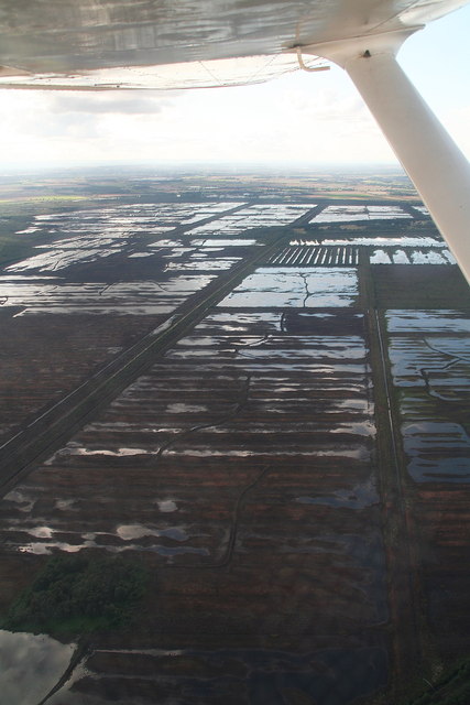
The highest maximum score in the balanced shortlist sits in the northern zone. The county-level label is useful, but the top-cell coordinates point to something more specific: a borderland landscape close to Hatfield and the Humberhead peatlands edge.

Why it surfaced
This zone combines low habitat share, very high connectivity, strong restoration scores, and relatively high agricultural-opportunity values. In plain terms, the model sees nearby ecological networks, real room for recovery, and a tradeoff profile that looks workable.
It also matters because it shows the shortlist is not dominated by the southwest. The model is finding a different kind of northern landscape: flatter, wetter, and more shaped by peatland and lowland restoration context.
What the place is like now
The highest-scoring cells geocode close to Hatfield rather than to the better-known interior landscapes of Nottinghamshire. Regional planning material describes Hatfield Moors as a remnant of once-extensive bog and fen peatlands and notes the restoration of degraded raised bog. That is a strong contextual fit for the model's signal.
For the public write-up, the safest interpretation is that this is a north Nottinghamshire borderland or Humberhead peatlands-edge opportunity zone. That wording is more honest than treating it as a generic county-wide Nottinghamshire result, because the spatial signal appears to be tied to a more specific peatland-restoration geography.
What still needs checking locally
- How far the opportunity is truly peat-driven versus broader habitat adjacency
- Boundary effects across county lines and cross-jurisdiction coordination
- Current restoration status and condition of nearby peatland assets
- Local land-use constraints, infrastructure, and delivery feasibility